
Quantification of Spatial Change in Natural Areas Within the Niagara Peninsula
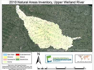
In an attempt to increase environmental awareness within the community and build a database a database that would be open for public and private use the Niagara Peninsula Conservation authority, with help from naturalist clubs and municipalities undertook a Natural Heritage Areas Inventory (NAI). The project was conducted between April 2006 and December 2009 with a goal of identifying, classifying and mapping natural heritage areas within the NPCA jurisdiction (NPCA, 2010). The NAI was created with emphasis placed on following stringent industry standards and scientifically based protocol (NPCA, 2010).
The Niagara Peninsula Conservation Authority now requires a geodatabase that will contain layers of feature classes that display the spatial change and fragmentation of these natural areas between 1934 and 2010, the year the NAI was completed. This geodatabase will serve to help the NPCA quantify and better understand the changes that have occurred in their jurisdiction. Staff at the NPCA should be able to easily identify areas and the degree of natural areas change, actual and potential locations of old growth forest and finally habitat associated with at risk species.
Project Benefits
-
An updated spatial inventory of natural areas
-
Quantification of changes of natural areas from 1934 to 2010
-
Identification of areas containing old growth forests within the NPCA jurisdiction
-
Visual comparison of natural area changes from 1934 to 2010
-
Identification of potential rare species habitat
-
Assistance in planning and policy decision making
-
Assistance in NPCA forestry department in guiding logging practices
-
Supporting sustainable forestry practices
-
Identification of potential areas for reconnaissance surveys
Project Goals and Objectives
The primary goal of this project will focus on creating a database containing a spatial inventory surrounding natural habitats within the NPCA Jurisdiction. The NPCA will possess statistics that quantify the levels of natural habitat change and fragmentation within the watershed using historical and current orthoimagery along with an updated natural areas inventory.
In order to satisfy the requirements of this project, critical objectives must be met. AML Solutions will take the time to create a spatial inventory of natural area habitat change from 1934 to 2010, report identifying areas of and degrees of change by municipality including nature of change (+,-, change in density), and create maps and statistics that identify the levels of change.
The Project
